| dc.description.abstract | Over the last 5-10 years, there has been accelerated geothermal resources development for geothermal power generation in order to meet the country’s electricity demands and hence make Vision 2030 feasible. However, owing to the tectonic setting of Kenya, earthquakes are likely to pose a threat and subsequent challenge to attaining Vision 2030 despite the numerous efforts made by the power sector players.
Earthquakes in Kenya are common along the Kenya Rift Valley due to the slow divergent movement of the rift and hydrothermal processes within the geothermal fields. This implies slow but continuous radiation of seismic energy which relieves stress in the subsurface rocks. It is therefore unlikely that the Kenya rift poses significant earthquake hazard in Kenya.
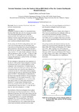
On the contrary, the NW-SE trending rift/shear zones such as the Aswa-Nyangia fault zone and the Muglad-Anza-Lamu rift zone are the likely sites of major earthquakes in Kenya and the East African region. These rift zones have been the sites of a number of strong earthquakes in the past such as the Mw = 7.2 southern Sudan earthquake of May 20, 1990 and aftershocks of Mw = 6.5 and 7.1 on May 24, 1990; the 1937 Ms = 6.1 earthquake north of Lake Turkana close to Kenya-Ethiopian border, and the 1913 Ms = 6.0 Turkana earthquake among others.
We have attempted to determine the source parameters of the May 20, 1990 southern Sudan earthquake by inversion of teleseismic body-waves, and the implications of this earthquake on the seismotectonics of southern Sudan, as well as the central and southern parts of Kenya. The results of teleseismic body-waves inversion show that the best solution for the May 20, 1990 southern Sudan earthquake consists of only one event on a fault having strike, dip and rake of 315o/84o/-3o. The fault plane is characterized by left-lateral strike slip fault mechanism. The focal depth for this earthquake is 12.1 km, seismic moment Mo = 7.65 x 10¹⁹ Nm and moment magnitude, Mw = 7.12 (7.2). The fault rupture started 15 seconds earlier and lasted for a duration of 17 seconds along a fault plane having dimensions of length 60 km and width 40 km. The average dislocation along the fault is 1.1 m and the stress drop, , due to this earthquake is 1.63 Mpa.
The distribution of historical earthquakes from southern Sudan through central Kenya generally shows a NW-SE alignment of epicenters. On a local scale in Kenya, the NW-SE alignment of epicenters is characterized by earthquakes of local magnitude Ml 4.0, except the 1928 Subukia earthquake (Ms = 6.9) in central Kenya. This NW-SE alignment of epicenters is consistent with the trend of Aswa-Nyangia fault zone, from southern Sudan through central Kenya and further southwards into the Indian Ocean.
We therefore conclude that, the NW-SE trending rift/shear zones are sites of strong earthquakes likely to pose the greatest earthquake hazard in Kenya and the East African region in general. | en_US |